The Fourth of July dawned bright and clear. Daniel and I packed up, crossed the Snake River to Clarkston and turned south along the river through Hell's Gate to Asotin, Wash., looking for a gas station to fill up. Then, in a repeat of yesterday's twisty descent into Lewiston, we climbed out of the Snake River Canyon and headed south.
Neither of us knew about the Rattlesnake Grade, a 13-mile stretch of twisties descending to the Grande Ronde River. It's 110 curves rival the Smoky Mountain's often-crowded Tail of the Dragon, but the Rattlesnake is a long way from any major population centers and we had it virtually all to ourselves.
As we wound our way along the Rattlesnake with me in the lead, I rounded a corner in a forested area as a cougar dropped gracefully off the slope to my left into the middle of the road. I was only about 50 yards away and it was unmistakeably a mountain lion. As soon as I spotted him I asked myself if I really wanted to stop, but he took one look at me and, in a bound, was over the guardrail on the down-slope side.
 |
| Rattlesnake Grade, Washington Hwy. 129, 13 miles and 110 curves of motorcycle fun, took us from Lewiston, Idaho and Clarkston, Wash. into Oregon. |
 |
| We rode down the grade from northeast to southwest. This satellite photo shows the route. A cougar jumped into the road 50 yards in front of me in Fields Spring State Park, the forested area at top right. Before I could decide whether it would be wise to stop, it jumped over the guardrail on the downhill side and was gone. |
 |
Daniel and I had a blast on Rattlesnake Grade and then stopped for breakfast at Boggan's Oasis on the Grande Ronde River at the bottom of the hill.
|
 |
| Entering Oregon, Wash. 129 becomes Ore. 3 and climbs to overlook Joseph Canyon, named for Chief Joseph, whose Wallowa band of the nomadic Nez Perce people once wintered in its shelter. |
 |
The town of Enterprise, Ore. was celebrating the Fourth of July with a downtown big flea market. We stopped to browse, but continued on to Elgin, where we stopped for a delicious lunch of fish and chips at Sig's Restaurant.
During lunch, Daniel and I both called home. Dan said his wife wasn't feeling well and thought he should cut the trip short -- heading straight back to Las Vegas and a plane home rather than exploring the Sierras with me. We'd had a couple of trying days -- enduring rain in Coeur d'Alene and strong crosswinds from there to Lewiston -- and a short, two-day ride to Las Vegas was enough for him. On the other hand, I'd promised myself to make it over the Tioga Pass from Yosemite to Death Valley. So, we decided to split up.
My goal, then, was to head west to Bend, Ore. and then turn south toward California. |
 |
| West of Baker City, Ore. are Strawberry Mountain, the state's 27th highest, and a giant Conestoga wagon set up by the local tourism agency. Actual Conestoga wagons, which were common on the Oregon Trail, averaged about 18 feet long, 11 feet tall and four feet wide. |
 |
US 26, the Ochoco Highway -- my route to Bend -- cuts right through the dramatic Picture Gorge, part of the John Day Fossil Beds National Monument, following Rock Creek, a tributary of the John Day River, which flows into the Columbia. |
 |
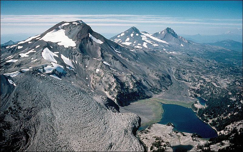
| From Picture Gorge, I had another 100 miles to go to spend the night at a gentrified former KOA campground near Bend. The campground was actually in Sisters, Ore., named for these three volcanoes (U.S. Geological Survey photo), and it was the most expensive camping on this year's trip -- $64 per night for a tent -- but I'd ridden more than 300 miles and needed to rest. Adding insult, the tent had to be pitched on the asphalt RV pull-in, not on the manicured grass. I bought oil and a filter at the Suzuki dealership in Bend on my way out of town.
|
 |
| It was a long day. Beginning in Lewiston (A), I rode the Rattlesnake Grade to Enterprise (B), headed west to La Grande (C), south to Baker City (D), turning west again through Picture Gorge, and camped in Sisters, just north of Bend (E). |


No comments:
Post a Comment