After my 430-mile trek on July 4 from Lewiston, Idaho to Sisters, Ore., I was a little slow to get up on Thursday, July 5. My faithful Wee-Strom needed was overdue for an oil change, so I stopped in Bend -- first at a McDonald's for breakfast and then at a Suzuki dealership for three quarts of synthetic 10W40 and a fresh oil filter.
Thus fortified, I headed south on US 97 toward California. We'd avoided freeways and flat, straight roads as much as we could, but this stretch turned out to be the worst so far on this trip. Nevada's deserts might be boring, but US 97 was utterly depressing despite its route through Deschutes and Winema National Forests and proximity to Crater Lake National Park. Except for a few small patches, the woodlands on both sides of the road were logged, leaving stumps and discarded branches, deformed older trees and scrawny new growth but removing all the prime, mature trees.
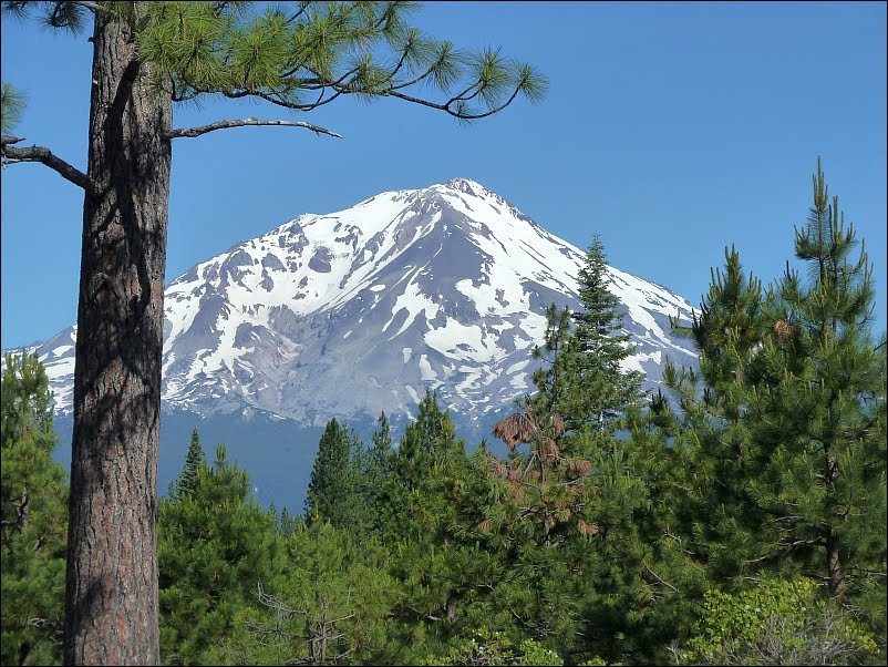
Things didn't improve much when I arrived at Klamath Falls, which sounded like an interesting and potentially scenic spot but turned out to be featureless, flat and drab. There are no falls at Klamath Falls, but as I left the area, Mount Shasta appeared on the horizon. What a sight!
 |
| For some reason, I only saw these signs in Oregon. While this advice is alien to us who live in Hawaii, the need for it does reflect poorly on the intelligence of Beaver State drivers. The logged-out scenery in the background was depressingly ubiquitous virtually all the dreary way from Bend to Mt. Shasta. |
 |
| Omitting the boring ride from Bend down US 97 through Klamath Falls to Mt. Shasta, Calif. (A), this was my route: First to Hat Creek (B); then Graeagle (C); Downieville (D); Auburn (E), where I spent the night; Placerville (F) and Big Tree State Park outside Arnold and near Angel's Camp (G). |
 |
| Rising from the dreary flats of Klamath Falls, where the elevation is 4,099 feet and there are actually no waterfalls, Mt. Shasta rises dramatically to 14,179 feet and is a joy to behold from as far away as 150 miles. A stratovolcano, Shasta is the second highest peak in the Cascade Range (Rainier at 14,411 feet is the highest), has seven glaciers and last erupted in 1786. |
 |
While Hawaii's anti-billboard law is perceived as overly fussy by some, there is something sacrilegious about slapping advertising on a sight as grand as Shasta.
I found a KOA campground in Mt. Shasta City, pitched my tent among giant Douglas fir trees and set about with my oil change. I had an audience of five kids from the next campsite. The oldest was to be in second grade come September; the youngest was perhaps four. I provided their entertainment for about two hours, since I'd packed an oil filter wrench but not a 3/8-inch ratchet handle to turn it.
I struck out when I asked at the camp office if any of the maintenance guys were around who might have a ratchet, but noticed they had some large hose clamps -- probably for RV liquid waste systems. I figured I could McGuyver the problem: I'd tighten the hose clamp around the spin-off filter and then bash the screw on the clamp with my hatchet to loosen the filter.
Of course, the hose clamp broke after I'd bashed it twice and the filter was still to tight to twist off by hand. So, I had to resort to the traditional solution, which was poking holes in the filter with a screwdriver and twisting it off while spewing dirty oil all over. This was a hit with the kids.
After cleaning up, I went to town and picked up an order of chicken in black bean sauce from a Chinese restaurant, washed it down with some red wine and hit the sack. |
 |
| Friday morning, I stopped for breakfast southeast of Mt. Shasta on Hwy. 89 in McCloud and admired these two pristine hot rods -- California car culture art objects. |
 |
| Another view of Shasta from along the road to Hat Creek, a tiny town dependent on hunting and fishing . |
 |
| Shasta can be seen from this overlook near Hat Creek ... |
 |
... as can Mount Lassen, the southernmost active volcano in the Cascade Range, which last erupted in May 1915. Lasses and Mount St. Helens are the only two volcanoes in the continental U.S. that have erupted since 1900.
The story of Mount Lassen's eruption was a new one for me. Although, like St. Helen's, its explosive eruption blew the top off the mountain and unleashed a lahar -- a wall of water, mud and ash -- that flowed four miles into Hat Creek, flooding the valley and destroying six houses, it didn't kill anyone. Few people inhabited the valley in 1915, and not many more do today.
|
 |
More than 140 miles by road from Shasta at Lake Almanor, the snow-covered peak was still clearly visible.
After filling up at Old Station -- the only gasoline
available within 60 miles -- I took Hwy. 44 toward Susanville before
turning south to Westwood, Clear Creek and Lake Almanor. There, I took
Hwy. 89 south through Crescent Mills and Quincy to Graeagle, a pleasant
resort town that was packed with holiday travelers, including a BMW
rider who was parked in the shade near the gasoline station.
We
had a chat and he told me he'd just ridden up from Sacramento taking
Hwy. 49 from Auburn. "That last 30 miles was the best motorcycle ride
I've ever had," he said. "Perfect, brand-new asphalt, winding through
the hills."
Needless to say, I struck out for Hwy. 49 and soon had my first view of the Sierra Nevadas.
|
 |
| The granite Sierra Nevada mountain range begins at the Susan River in the north, seen here from Gold Lake, and runs south to the Tehachapi Pass near Bakersfield. The name "Sierra" comes from the Spanish for "jagged mountain range," which in turn comes from the Latin "serra," which means "saw." "Nevada" comes from the Spanish "nevado" for "snowy." |
 |
| Downieville was a welcome stop after 30 miles of newly paved, curvy asphalt on Hwy. 49 from Graeagle. A BMW rider I met in Graeagle said it was the best motorcycle road he'd ever ridden. Apparently, he hadn't been to Rattlesnake Grade, although the scenery along Hwy. 49 might have topped the Rattlesnake's. It was the kind of afternoon when folks just sat in the shade outside the grocery store to talk story. |
 |
| The Pacific Coast Highway has its charms, but Calif. 49 -- the Golden Chain Highway, named after the 49ers of the 1849 California gold rush -- is in the same category: great motorcycle road. Connecting the mining towns of the Sierra Nevada from Vinton to Oakhurst, passing by Yosemite National Park along the way. |
 |
This perfectly restored Jaguar XKE roadster enjoyed a shady parking spot in Downieville. If I had to choose an alternative vehicle for Hwy. 49, it would do nicely.
South of Downieville, the fresh asphalt ended, but the ride through Grass Valley to Auburn was still a pleasant end to a great ride through parts of Northern California I'd never visited before. By the time I arrived in Auburn, I was too tuckered to camp, found a motel for the night and picked up dinner at the Wienerschnitzel restaurant next-door.
|


No comments:
Post a Comment