Monday, May 24, 2010

Nebraska and the end of the road


When Mary, my beloved and long-suffering wife, who has tolerated my motorcycle adventures, suggested I really should visit Carhenge, I didn't want to disappoint her. She grew up in Nebraska and has a keen appreciation for Cornhusker culture, especially its whimsical expressions.

Carhenge isn't just a fanciful recreation of the iconic and prehistoric engineering feat erected in 3100 B.C. in England. No, it's more. There are also sharks, dinosaurs and giant daisies all made out of pieces of American cars, vintage 1950s and 60s.


A steel shark rises out of the fertile soil of western Nebraska.

To get there, I headed west from Gordon and then south to Alliance, a town of 9,000 with a flair for marketing. Formerly dubbed Grand Lake, despite the absence of a body of water deserving that name, the town got its current name thanks to the superintendent of the railroad that arrived in 1888. G.W. Holdredge said a simple, one-word name beginning with a letter close to the beginning of the alphabet would be better for business.


Carhenge, the creation that put Alliance, Neb., on the map.


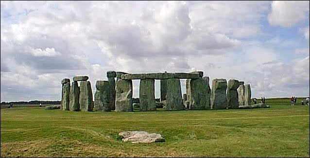
The so-called "real" Stonehenge. If they'd had cars back in the day, they probably wouldn't have used rocks.

There were no crowds at Carhenge when I arrived nor anyone charging admission. A metal farm building, the "Pit Stop" visitor center and gift shop, anchored one end of the dirt parking lot, which opened into a field filled with weeds and, ... ah, sculpture. A tractor pulling a liquid fertilizer wagon worked the adjoining field.


A vintage, mid-50s Cadillac forms a graceful cross-piece.

According to the official Carhenge website, "38 automobiles were placed to assume the same proportions as Stonehenge with the circle measuring approximately 96 feet in diameter. Some autos are held upright in pits five feet deep, trunk end down, while those cars which are placed to form the arches have been welded in place. All are covered with gray spray paint. The honor of depicting the heel stone goes to a 1962 Caddy."

Wikipedia notes: "Other works have been built in the surrounding area of the sculpture."


Other works built in the area don't include the tractor on the right. Yet.

According to the story, "Carhenge was built as a memorial to Reinders' father who once lived on the farm where Carhenge now stands. While relatives were gathered following the death of Reinders' father in 1982, the discussion turned to a memorial and the idea of a Stonehenge replica was developed. The family agreed to gather in five years and build it. The clan, about 35 strong, gathered in June 1987 and went to work. They held the dedication on the Summer Solstice in 1987, with champagne, poetry, songs and a play written by the family."


Gray primer sprayed on the cars unifies the work.

Stonehenge is a place of pilgrimage for neo-druids, and for others of pagan or neo-pagan beliefs. While I was there, Carhenge was mostly a place of pilgrimage for groups of motorcyclists and folks in RVs stopping for a laugh and to take pictures.


Visitors are dwarfed by the enormous work of art.

OK, so much for whimsy. After stopping in Alliance for a sausage McMuffin with egg and a senior coffee, I was off toward Scottsbluff to visit Chimney Rock, the other Nebraska "must see," according to Mary.

"It's on the Nebraska state quarter," she said, leaving no room for argument.


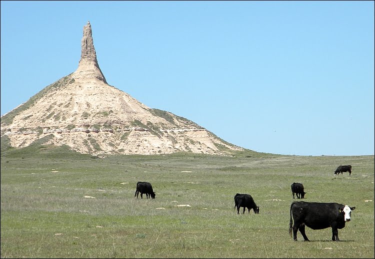
Chimney Rock is a National Historic Site, one of the most recognizable landmarks for pioneers on the Oregon, California and Mormon trails.

I missed Chimney Rock on my first pass through Scottsbluff a few days before but I agreed to return to check it out, since Mary explained that it was Nebraska's equivalent to Hawaii's Diamond Head -- a revered icon.

It does get one's attention, rising vertically for 300 feet out of grasslands, which a herd of Angus was diligently harvesting.


Flanman reflects on his image in a window at the Chimney Rock visitor center.

Many pioneers travelling west reported they carved their names or initials into the rock's soft sandstone, but these have been erased by erosion. The rock was taller and thicker in those days, according to historical records, but time rain and wind have gradually worn it down.


From another angle, the wear and tear of erosion is apparent.


The state quarter celebrates the monument.

It was a busy morning, but leaving Chimney Rock I had a lot of ground to cover. I doubled back to Alliance to take NE 2 through the Sand Hills to Bertrand, Neb. -- journey's end. The wind was howling from the west, but I was headed due east, so it wasn't a bother, yet.

The Sand Hills are 23,000 square miles of dune-like mounds of grass-covered sand that sit atop the Ogalala Aquifer, 85 percent of which is untouched natural habitat that has never been plowed. Between the dunes are many shallow natural ponds and wetlands. Most of towns along NE 2 are tiny and unincorporated, joined together by the highway and the busy railroad, where 100-car trains carry coal from Wyoming mines to cities to the east.

For me, the challenge was to stay alert and on course as he KLR droned its way through the dunes on the gently curving two-lane highway. On this Sunday afternoon there was almost no other traffic as we passed the laden freights moving east and the empties speeding west for another load. I stopped in Mullen for a sandwich and a Monster energy drink and again in Thedford to refuel.

I decided to head south on US 83 at that point after checking my watch and how far I had to go before nightfall. Good move.


Nebraska's Sand Hills sit on a huge body of underground water.

Turning to the south, the wind cut across the road, now out of the east. I shifted my weight and leaned out to the left side of the bike to balance the steady breeze and brace for gusts. It was 66 miles to North Platte -- about an hour of wrestling with the crosswind. As I neared the city, a huge black storm cell towered above it. Turning east on I-80, I'd be running away from it.

In nearly seven weeks on the road, I'd gotten wet only a few times. There was a two-hour dousing between Waco and Austin, Texas, a snow shower coming over the pass into Flagstaff, another heavier snow shower in Monarch Pass, Colorado, and a few minutes of downpour riding from the motel to dinner in Sturgis, S. Dak. That was all, but it appeared I needed to get indoors soon or there would be a good soaking.

Bertrand, my wife's hometown, was 82 miles away, but I had a tailwind again and the weather gods were patient. I arrived at her dad's farm covered with dead bugs but five minutes ahead of the thunderstorm that had been stalking me from North Platte.

You honestly haven't seen a real thunderstorm till you've seen one in Nebraska.

The ride was over.

Now it's time to write it up, think about it and try to record what it all meant.

Sunday, May 23, 2010

Good times in the Badlands


After a pleasant Saturday morning in Sturgis, a ride through the Black Hills to Rapid City and then east to Badlands National Park was next on the agenda. My friend from the Motorcycle Museum suggested a route through Deadwood, an old gold mining town that has reinvented itself as a casino gambling resort.

Named for the many dead trees that conspicuously decorate its gulch (South Dakota doesn't have "canyons," it has "gulches"), Deadwood was a famous center for prostitution, opium and other vices every since its founding in 1876 and became most famous as the scene of the murder of Wild Bill Hickok and the final resting place for Wild Bill and his girl friend, the scout and Indian fighter Calamity Jane.


Deadwood, S. Dak., is a town full of ersatz Old West charm, and lots of casinos.


The town has cleaned up well and there were no gun fights during my short visit, but it doesn't take long for me to tire of its Wild West shtick.

Several folks told me the story of Wall, S. Dak., a tiny town on I-90 -- the former US 40 -- near Badlands National Park. A Nebraska druggist named Ted Hustead and his wife Dorothy bought the pharmacy there in 1931 but found it was hard to make a living. Dorothy came up with the idea of advertising free ice water to tourists headed to Mount Rushmore across the parched prairie and business took off.


Wall, on the other hand, is full off ersatz Old West charm, without casinos.


Wall Drug Store grew into a sizable shopping center offering restaurants, gift shops, an art museum, chapel and an 80-foot long dinosaur -- all with a cowboy theme. Billboards along the highway from Rapid City still advertise free ice water and 5-cent cups of coffee. The pitch still works -- the parking lot was jammed with cars despite the fact that the highway to Wall was largely deserted.

From Wall, it's a short drive to Badlands National Park, where the ranger at the gate warned me that about half the 20-mile road through the park was torn up for repaving. "Well, that'll be an adventure," I said.


A visitor's first sight of the Badlands is breathtaking.


The landscape isn't as colorful as Bryce Canyon, for example, but it is equally intricate.


The Badlands, like the canyons of Utah, have been shaped by erosion. The material is much softer than the limestone and sandstone of the southwest. The White River flows through much of the park. Swelled by recent rains, the river lived up to its name carrying tons of white silt downstream.


The Badlands rise out of the surrounding prairie, but not too high.


The flagman directing one-way traffic through ten miles of the park got tired of standing.

In a way, the Badlands is sort of the munchkin version of Utah. There are many of the same features: canyons, buttes, cliffs, etc. But they are much smaller. Some of the smaller mesas, for example, are only five feet tall.


Badlands' scenery might be compact, compared to Utah's ...


... but it is no less dramatic.

The road through the park connects Wall on the northwest with Interior on the southeast. From Interior, I headed south into Nebraska through Indian country through Allen and Batesland near Wounded Knee and across the state line to Gordon, Neb.

I had no difficulty riding south, but when I turned to the west through Batesland a heavy crosswind began blowing me all over the road. My goal was to reach Alliance, Neb., but by the time I got to Gordon it was too windy to keep going. So, I found a motel and settled down for the night. Tomorrow, I'd check out the wonders of the Nebraska Panhandle: Chimney Rock and Carhenge.


Saturday, May 22, 2010

Drawn to Sturgis, like a moth to the flame


This was not the scene when Flanman arrived in Sturgis, S. Dak.


In fact, Main Street looked like this during my visit.

Sturgis. The American motorcycle Mecca. The destination for an annual hajj of legions of disciples of the mighty V-twin.

Last August, an estimated 750,000 people showed up for the big rally. The population of the entire state is about 812,000 -- so it's a pretty big deal.

I arrived on Friday, May 21 -- two months early -- accompanied by a Badlands thunderstorm. I slid off I-90 from Rapid City, cruised downtown to get my bearings, checked into the Starlight Motel and gave the rain a chance to stop.

No dice.

I put my gear back on and headed downtown to the Loud American Roadhouse on Main Street. The place was hopping, even though the KLR was the only two-wheeler parked out front. NASCAR, hockey and baseball were playing on the flat screens and the horseshoe bar in the center of the big room was doing a brisk business.


The Loud American Roadhouse is one of many large saloons that cater to the August crowds.

I hung my soggy jacket on the back of a stool and took a seat at a tall table. Then things deteriorated.

I ordered a glass of cabernet. After a few minutes, a waitress brought a glass of chardonnay. When she came back with the red wine I ordered, it was undrinkable.

"Would you like a shiraz instead?" she asked. I asked for a Miller Lite and ordered the steak tips dinner, which came with a salad or soup -- the soup choices were cheeseburger or beef stroganoff.

I ordered the beef stroganoff soup and minutes later the steak tips arrived. "Don't you usually bring the soup first?" I asked. The waitress apologized and brought me a cup of the cheeseburger soup.

"Is everything OK?" she asked. "Well, now that you mention it ...," I said.

She took the cheeseburger soup away and brought a cup of the stroganoff and a check.

The total was $0.00 -- they comped the whole dinner. The waitress said they were really sorry they'd screwed things up so bad and she hoped I'd come back and give them another chance. Nice people.

It was still raining and, heck, I was just happy to be indoors where it was dry.


Our May 22 rally consisted of me and this guy from Washington.

Next morning, the rain had stopped and I packed up, checked out, went down to Main Street and had breakfast at Weimer's Donuts and Diner. There were three calendars on the wall and the place was full of local folks and conversation, including a discussion of what the city was doing with the streetlights.

The city fathers decided to replace the existing lights with some with a more Old West or Victorian Era look, but rather than replace the old light poles, they'd begun to saw them off to fit the theme. Then, someone came up with the idea of memorializing long-standing businesses with bronze medallions glued to the poles.

"I wasn't going to do it," said the woman who runs the diner. "It seemed like a lot of money. But then I thought, gee ... we've been here since 1949, and I went ahead."


Weimer's Donuts and Diner is now memorialized on this lamp post. Presumably, the pole will get a coat of paint when the new lamps are installed.


Sturgis isn't such a happening place between rallies.

After breakfast, I headed over to the nearby Sturgis Motorcycle Museum, also on Main Street, which is located in the old Sturgis post office building.


The Sturgis Motorcycle Museum is worth a stop.

"With several exhibit rooms and an increasingly impressive selection of unique motorcycles, the Sturgis Motorcycle Museum offers a world class experience for visitors and has been listed as one of the 10,000 Places to See Before You Die by author Patricia Schultz," says the museum's web site.

Well, I wouldn't rank it up there with Yosemite and Mount Rushmore, but 10,000 is a lot of places.


The 1949 HRD Vincent Rapide's engine is a lovely piece of motorcycle art.

Since I was virtually the only visitor, the curator du jour gave me a personal guided tour, pointing out highlights, such as pre-1910 Harley's and Indians and an Electra Glide that Wisconsin State Senator Dave Zien rode 1 million miles flying U.S. and Wisconsin flags.


Zien's million-mile Harley has had numerous engine rebuilds. The fenders and a few other parts are original.

Although the Jackpine Gypsies Motorcycle Club didn't inaugurate the annual Sturgis Motorcycle Rally until 1938, the museum has a fine collection of bikes that predate the big party, including a 1905 Excelsior, 1910 Flying Merkel and a 1913 Harley Davidson. The newest model is a gorgeous 1999 Excelsior-Henderson Super X, still in the shipping crate. It was an instant classic, since only 2,000 were built before the Minnesota company went bankrupt.


Several of the antiques in the collection are pristine, like this old Harley...


... and this pre-WWI Indian, which looked fresh from the factory Valve covers? We don't need no stinking valve covers!


Among the "classics" on display was this 1967 Honda 305 Dream -- my very first motorcycle.

I was delighted to find a 1967 Honda 305 Dream among all the classic racers and groundbreaking examples of two-wheel engineering. I bought a used Dream for $400 back in 1965 when I was in the army stationed in Colorado Springs and rode it all over the area, including up the Rocky Mountain dirt roads to the old mining towns of Cripple Creek and Victor. With its stamped steel fenders and frame, the Dream was designed more for civilized urban commuting, but who could resist the call of the wild?


My Dream was black and didn't have these snazzy saddlebags.


That Honda engine was a pretty design. The bike came with electric start, but the kick starter was essential.

Friday, May 21, 2010

More sights to see, north by northwest


Heading northeast out of Boulder, I was soon out in the prairie.

Lafayette, Colo., was a good place to stop and rest up after my loop down to Santa Fe and back up through Texas and Oklahoma cattle country and lots of southeastern Colorado grasslands. Thanks to my sister-in-law Jane Marshall, I was able to get caught up on the blog, do my laundry and even -- after I found some NikWax cleaner in Boulder -- wash the bugs out of my riding suit. I confess I left some oil spots on her driveway getting the oil changed, but after the run from California to Colorado it was time.

My Honolulu bike buddy Daniel Niide introduced me to Stephen Lam, who restores vintage Suzuki Katanas -- superbikes of the 1980s and 90s -- at his place just up the road in Longmont. I rode up there to pay a visit and covet Steve's immaculate creations. Besides being an expert mechanic and machinist, Steve knows where to go in northern Colorado for genuine Vietnamese pho and we had a great time talking bikes while eating spicy noodle soup and chicken wings.

Next morning, Jane found me at the dining room table puttering on Google maps trying to decide where to go next. Wyoming seemed to be the probable destination and I was researching the weather in Yellowstone, Jackson Hole and the Grand Tetons with some trepidation. Some roads were still closed in the area because of recent snow storms and camping again at altitude didn't have much appeal.

She suggested, why not go up to South Dakota's Black Hills and Badlands? They are just north of the Nebraska state line and from there you can check out the Nebraska panhandle and sand hill country on your way to the big Memorial Day family reunion in Bertrand.

For some unknown reason, I'd thought Rapid City, Sturgis and the Black Hills were much further north -- up in North Dakota, I guess. Now that I had an alternative to Wyoming frost bite, I was ready to go. In fact, I packed up and left that Thursday afternoon. I'd see Jane and her family again in a week and a half at the reunion.


In Gering, the neighbor to Scottsbluff, I found a pleasant campground near the bluff itself.


My plan was to ride up to Scottsbluff, Neb., on Thursday and to spend the night camping at Lake Minatare, which is locally famous for being the only lake in Nebraska with a lighthouse. The Civilian Conservation Corps built it during the Great Depression to shine a beacon of hope for those living in the region.

Unfortunately, the beacon isn't doing its hope job lately. I arrived at Minatare, the town nearest the lake, almost out of gas to find the filling station, restaurant and motel all closed, boarded up and for sale. Looping through the town, I discovered all the other businesses were also shut down, except for a small grocery store and one bar.

So, I turned back to Scottsbluff on the north bank of the Platte River to refuel and find a meal and a campsite.


Scottsbluff made a pretty picture in the morning.


The bluff is a national monument and part of a ridge of cliffs along the south side of the Platte River that rise unexpectedly from the surrounding prairie and forming a scenic skyline. Scottsbluff, combined with the town of Gering on the river's south bank, is the largest metropolitan area in the Nebraska Panhandle.

I found a pleasant new campground in Gering, pitched the tent and had dinner at a nearby Chinese restaurant, where I was the only Thursday night eat-in customer. Things were much busier the next morning at the cafe in the old passenger depot near the Scottsbluff zoo. There were two calendars on the wall and everybody who came in that Friday morning, except me, was a regular. The ham-and-eggs special arrived quick, hot and accompanied by a joke:

"There were these two guys fishing in a boat near a bridge. After a bit, a hearse and a funeral procession come across the bridge. One of the fisherman stands up in the boat, takes off his hat and holds it over his heart. 'What's the deal with the hat?' asks the other fisherman. 'Well, I was married to her for 32 years,' says his buddy. 'It's the least I can do.'"


North of Scottsbluff I passed through the Ogalala National Grasslands.


Next stop on my way to South Dakota was Chadron, Neb., where I noted the reading on the odometer: 33,480.5 miles. When I set out from Ellsworth, Me., on April 7, it read 23,405. I'd passed 10,000 miles -- and 21 states and the District of Columbia, so far -- in just over six weeks on this trip.

There was a Kawasaki dealer in Chadron with a KLR parked out front. I stopped and asked if they happened to have replacement clutch and brake levers. The young man behind the parts counter said, "Yep, we probably do, since I ride one."

I already had a set of levers on order to be delivered at Jane's place in Lafayette, but they didn't arrive before I left town and I figured the way I seem to go through these parts having a spare set wouldn't be a bad thing.


At Wind Cave National Park in South Dakota they let the bison run free.


You drive over a cattle grate to enter Wind Cave National Park in southeastern South Dakota, but it's not to keep cows in. They have a herd of buffalo roaming, running and occasionally charging through the park instead. But the main subject matter is underground, where there is a network of hundreds of miles of caverns.

I stopped at the visitors center and worked my way through the exhibits. The next tour wasn't to start for more than an hour and I hadn't felt any yearnings for spelunking since my visits to Mammoth Cave and Carlsbad Caverns, so I opted to move on to Mount Rushmore.


Mount Rushmore has an elaborate new visitor center and parking structure. Note the tiny workers atop Lincoln's head (click image for a larger version).

Ten dollars seemed like a lot to park a motorcycle, but I'd come a long way, so I coughed it up and climbed the stairs out of the parking garage to the spiffy visitor center, gift shop, ice cream parlor, amphitheater and cafeteria at the foot of Mount Rushmore.


Washington and Jefferson look down on the flag of Hawaii, which became a state 172 years after the U.S. Constitution was ratified.


I was happy to see Hawaii's flag hanging in the colonnade leading to the overlook, where some young scientists were working with fellow team members who were up on the sculptures themselves to record a three-dimensional, digital scan documenting the exact dimensions of the existing work -- in case pieces break off in the future.

The tiny human forms up on the huge likenesses brought to mind Hitchcock's North by Northwest, which featured Cary Grant and Eva Marie Saint crawling on the presidential faces.


There are telescopes for those who want a close-up look.


The best photo I could manage on a cloudy day.

A gaggle of mountain goats wandered about the visitor center, upstaging the granite heads and providing additional subject matter for photography.


A mountain goat poses for pictures at the monument visitor center.

Unfortunately, the skies were cloudy. I waited for the sun to peek through to provide more shape and contrast to the scene, but had to settle for what I could get.


The photo on the Coke machine near the mens restroom was better than any of mine.

Wednesday, May 19, 2010

Crossing Oklahoma off my list


Last summer, I made the mistake of riding north from Savannah, Ga. without taking the time to go to Florida. It's only 139 miles from Savannah to Jacksonville, but because I didn't go south I won't be able to say I've motorcycled in every state without quite an extra effort.

This trip, I planned to cross the southeastern corner of Oklahoma on my way from Hot Springs, Ark. to Austin, Texas. The route the GPS selected turned out to be different from the one I Googled on my laptop, however, and I missed Oklahoma. I also missed Santa Fe -- a city I fell in love with a few years ago when Mary's family met there to spend Christmas.


From Salida to Canon City, US 50 follows the Arkansas River.

So, with nearly two weeks left before I needed to be in Nebraska for another family reunion, I decided to ride down to Santa Fe and then loop east to Oklahoma before circling back to visit Mary's sister Jane's family in Lafayette, Colo., near Boulder.

Sunday, May 16, dawned clear and crisp and I followed US 50 east along the Arkansas River to Canon City and Pueblo. No mountain passes this time, just a winding road following a beautiful river boiling with snowmelt. I stopped at the Royal Gorge along the way, but decided to pass up crossing the nation's highest suspension bridge or riding the incline railway to the bottom of the gorge. The commercial, theme-park atmosphere turned me off after visiting so many national parks.

After Canon City, the road flattened out through Pueblo, where I turned south through Colorado City and Walsenburg before jogging southwest toward Taos along the straight valley highway with the Sangre de Cristo mountains to the east. As the day warmed, the KLR hummed and the straight, flat road disappeared into the shimmering distance, I needed something to keep me awake and stopped for an energy drink in Fort Garland, which Kit Carson had commanded back in its days as a frontier military post. A can of Full Throttle and a bag of jelly beans did the trick.


We were back in New Mexico, this time arriving from the north.

Arriving in Taos in the mid afternoon, I could appreciate the cities style and attractions, but they just made me want to keep going to Santa Fe. I stopped for gas and to pick up a New Mexico road map -- the one I used on my trip west through the southern part of the state had blown out of the tank bag near Silver City -- but then got rolling again down NM 68, which took me to the Rio Grande gorge and then followed the banks of the river -- much larger here in northern New Mexico than down on the Texas-Mexico border -- down to Espanola.


The Rio Grande in northern New Mexico is a favorite spot for rafters, kayakers and fishermen.

In Espanola, there must have been a convention of three-wheeled motorcycles with V8 engines. I saw three of these exotic machines in different palace, not in a group, and one of them turned up later at the Plaza in Santa Fe.


I spotted three of these trikes with Chevy V8s in Espanola on my way from Taos to Santa Fe.

That Sunday evening was a perfect time to arrive in Santa Fe. I spotted a campground just outside the city in the Santa Fe National Forest and, after pitching my tent there, I headed back into town for dinner. The setting sun washed the town with warm color and street musicians played in the Plaza.

I limped around the downtown area -- the ankle I twisted on Monarch Pass was better, but not 100 percent -- checking out menus outside high-end restaurants and ended up back at the Plaza Cafe, which claims to be the city's oldest restaurant, founded in 1918. I chose pollo adobada, wanting to compare it to the chicken adobo served in Hawaii. Both dishes include chicken and a spicy sauce -- that's about all they have in common, but both are delicious.


Santa Fe's distinctive architecture is a delight.


The cathedral in Santa Fe at sunset.


If you squint, Santa Fe almost disappears into the desert.

The night camping in the Santa Fe National Forest was relatively warm and very dry -- a happy change from the frigid temperatures of Bryce Canyon or dewy nights that left everything soggy. In the morning, I packed up and rode back to Santa Fe for huevos rancheros at the Plaza Cafe and then wandered around taking a few pictures and enjoying the morning's perfect weather.


Local artisans sell jewelry at El Palacio Real, the oldest public building in the U.S.


Santa Fe's quiet downtown plaza is a great place to relax.


Santa Fe locals stop for a chat outside the Contemporary Museum.

But I was a man with a mission: to ride a motorcycle in Oklahoma. So, I mounted up and rode southeast on US 84, paralleling the old US 66 highway, looping around the mountains to Las Vegas, N. Mex., and then heading east to Tucumcari -- a town which, for me, wasn't as interesting as its name.


Santa Fe architecture incorporates the colors of the desert.

I saw a lot of desert that afternoon. The blue verbana wildflowers, tan soil, evergreen bushes and golden grasses echoed the colors of Santa Fe, one of my favorite American cities.


The road to Tucumcari, which includes sections of the historic US 66, took me through some wide 0pen spaces.

Meanwhile, the straight, flat roads of northeastern New Mexico again eroded my ability to stay alert and I stopped at a decrepit gas station slowly disintegrating along a section of the old US 66 and bought a sandwich and a Monster energy drink. I met two other riders, from Minnesota, at the station. They were headed to Moab and Bryce Canyon and said they planned to camp. I wished them good luck but told them to expect cold temperatures. Moab shouldn't be too bad, but Bryce, at over 8,000 feet, would still be frigid.


Getting to Oklahoma took me back to Texas.

I-40 took me to Tucumcari, where I turned northeast on US 54 to Logan and past Ute Lake, an area working hard to become a recreational mecca, despite a harsh, uninviting environment. Beyond Ute Lake near the Texas border there is a town on the map, Nara Visa, that appears to be a modern ghost town, although it claimed 112 inhabitants in the 2000 census.

Back in 1919, according to Wikipedia, "Nara Visa had eight saloons, at least three dance halls, drugs stores, general merchandise stores, a barber shop, butcher shops, millinery shops, auto suppliers, hotels, garages and a bank." These days, it has a row of junk cars spray painted with the legend: "Go Away!"


A hawk keeps an eye out for a meal from his perch overlooking the Texas prairie.

Crossing the state line into Texas lifted my spirits. I was in cattle country -- wide-open prairie with more grassland than desert and lots of windmills pumping water in the pastures. I stopped to take a photo and spotted a big hawk perched in a tree. Miles away, there was a homestead on the horizon. Other than that ... grass.


Dalhart, Texas, is a bustling cow town where the bank stays happy.

Crossing into Texas, I lost an hour, switching from Mountain to Central Time, and it was time to find a place to stay for the night. Neither the road map nor the GPS detected any campgrounds within 60 miles. I worked my way north to the city of Dalhart, passing two enormous cattle feed lots -- each with thousands of head of cattle.

Dalhart keeps alive the legacy of the XIT Ranch, a three million acre spread that was acquired in exchange for building the state capitol in Austin. The ranch was broken up in 1912, but the name "XIT" is still common in the area.


Dawn in cattle country.

I got up early with 365 miles to ride to Lafayette, Colo. The forecast was for rain and strong thunderstorms in the afternoon along my route.


I made it to Oklahoma.

As the sun rose, I found myself at the state line and stopped to document my passage into Oklahoma and the Rita Blanca National Grassland. A few miles up the road in Boise City, Okla., I stopped to fill the KLR's tank and then continued north into Colorado and the Comanche National Grassland.

I stopped at the Campo (Colo.) Cafe for breakfast. The special was sausage, eggs and hashbrowns. A sign on the wall said: "Trust your neighbor, but brand your cattle." There were three calendars on the walls.

Around a long table in the middle of the dining room a half dozen local guys in denim and cowboy hats sat discussing technology.

Turns out, every one of the six had at least one light on the dashboards of their pickup trucks that wouldn't go out and had been that way since the trucks were new -- either the "check engine" or air bag warning light or something. What's more, one fellow had installed a GPS in his truck that was draining the battery -- it just wouldn't shut off when he turned the key. "Must be some kind of relay in there," he said.

"That old pickup of mine runs through gas faster than I can pay for it," said his friend.


They grow a lot of wheat in this part of the country.

My road ran north from Lamar to Kit Carson, then northwest to Hugo, Limon and Denver. A strong tailwind pushed me along, easing the pressure on the bike. Nearing the Denver airport on I-70, I saw a huge black cloud ahead spitting lightning and stopped to button up and put a ziplock bag over the GPS.

Luckily, the storm was headed northeast and had passed me by before I reached I-270, the northern loop around the city. The highway was still wet, though, and I arrived in Lafayette splashed with grime. Still, 365 miles in seven hours was good time on a big ol' dirt bike.


My route from Salida to Lafayette took me through four states.