
I was up early on Saturday morning, packed and on the road before the rangers started collecting park fees at the gate to Cape Breton Highlands National Park -- they just waved me through. I skipped breakfast to get a jump on the day, figuring I could wait until I reached a town up the road.
The views were spectacular, the skies clear and crisp, and the road followed the mountain sides above the ocean with an occasional dip almost to sea level followed by a climb to 300 meters or more. There were almost no cars and few motorcycles, but a group of several dozen early-rising bicyclists were strung out across the first few miles.

Cape Breton is geologically the northern end of the Appalachian Mountain chain. The island is roughly the size, at 3,981 square miles, of Hawaii's Big Island, which has 4,028 square miles. Somehow, I'd expected something smaller.
The ranger warned me to watch out for moose Friday evening when I stopped at the park visitor center. "They come out during the day, not just in the evening like the deer," she said. Sure enough, about ten miles from the park entrance I spotted one standing in the road. Happily, it ambled off into the woods.

No, this isn't my photo, but coming down this hill there's no real vantage point where you can photograph this precipitous drop from the high plateau to sea level through eight switchbacks. It was pure delight to ride.

I stopped at Neils Harbor looking for breakfast, but the restaurant was still buttoned up.

Some gulls are more equal than other gulls.
I finally found a meal in Ingonish, which is more a resort town than a commercial harbor, just outside the southeast corner of the national park. Other patrons at the café were planning hikes, golf outings, beach walks and tennis matches. They didn't take credit cards and I hadn't had any luck withdrawing Canadian currency from an ATM, despite having called the bank before my departure to let them know I'd be out of the coountry. Luckily, however, they accepted my U.S. $10 bill.

Unexpectedly, when I reached Englishtown, the road across a breezy inlet ended about 300 yards short of the opposite bank. I was first in line waiting for the ferry that would take vehicles across the gap for $5.75. Again, no credit cards, but they were happy to take $6 in U.S. cash for my fare.

The wind and current were flying down the inlet and out to sea and I wondered how the ferry was able to stay on course against the sideways forces. Then, I saw it just pulled itself across on a cable strung between the ferry landings.

From the hill above the southern side of the inlet, I could see the causeway leading to the ferry.

From Englishtown, I rode the Mabel and Alexander Graham Bell Way over a ridge and down the other side to this bridge that spans the Bras d'Or, a huge, salt water lake 100 kilometers long and 50 kilometers wide. The inventor of the telephone built a home and laboratory in Baddeck, overlooking the lake, and spent the last years of his life living and working there.
In Sydney, the island's largest city with a population of 37,500, I stopped for lunch and decided not to take the ferry to Newfoundland. I'd seen a lot of trees and beautiful coastline and figured there was no way Newfoundland could top Cape Breton. Besides, although I'd enjoyed two consecutive sunny days the forecast was a wet one. September was already too late in the year to expect clear skies.
So, I got back in the saddle and enjoyed a pleasant ride west along the lakeshore to Port Hawkesbury and Antigonish and stopped for the night at Dolan's Inn in Pictou.

The day began at Chéticamp (A) where the road wound up into the hills to Pleasant Bay (B), Dingwall (C) and Neils Harbor (D) and out of the national park south to the Englishtown Ferry (E) and Sydney (F). After a bite to eat, I rode down the Bras d'Or Lake shore to Port Hawkesbury and the Canso Causeway and continued west to spend the night in Pictou (G).

Sunday's dawn brought gray skies and a spatter of raindrops. I put my GoreTex rainsuit on over my armored GoreTex riding suit, strapped rain covers over my "waterproof" boots, pulled on my international orange vinyl lobsterman gloves and headed for the Digby-Saint John ferry. The rain grew to a constant drizzle by the time I stopped for lunch and fuel in Windsor and from there to Digby it poured.
After a short stop in Annapolis Royal, a beautiful old town full of well-tended colonial and Victorian homes, I arrived in Digby, boarded the ferry and strapped Ol' Yeller down next to a Harley for the crossing.

By mid-channel, the rain had stopped and the skies were blue, but the decks were still wet.

The ferry crossing takes three hours, but the ship is well-equipped with a large cafeteria, lounges serving beer and wine and featuring big-screen TVs. I watched the 49ers beat the Packers.

In the cafeteria, I asked for a small order of poutine. I'd seen this local delicacy on the menus at many restaurants and fast-food outlets, but didn't know exactly what it was. Turns out, poutine is french fries covered with shredded mozzarella and topped with gravy. The chef on the ferry said most people use chicken gravy, but he was out of that, so I'd have to settle for beef gravy. Yum!

As Saint John rose above the horizon, it was time for passengers to gather up their belongings and head down to the vehicle decks to prepare to drive off.

My final day in Nova Scotia was a long, wet one, beginning in Pictou (A), rolling down to the Halifax suburbs (B) and through Windsor (C) to Digby (D) and the ferry over the bay to Saint John.
I had a reservation at a motel just four miles from the ferry dock in Saint John. Since I'd dropped and broken the GPS that I'd installed the map of Canada on and my backup GPS had only the U.S. map, I studied my route to the motel on my iPad on the ferry and thought I had it down.
Unfortunately, I got lost in the maze of streets near the harbor. I could have used my phone to find my way, but I'd been warned about Canadian cell phone data charges, left the phone off and relied on the kind assistance of the locals. I also stopped at the same Tim Horton's three times to use the wi-fi to chart a course.
Neither Google Maps nor Apple's map app were very responsive. It turned out that I was using the google.com/maps website and I should have been using google.ca/maps. Once I figured that out, I was able to find where I was, where the motel was and finally arrive -- almost two hours after the ferry landed. Doh!

Monday was crisp and clear. I bundled up and found my way to the U.S. border crossing at Saint Stephen, New Brunswick and Calais, Maine. There were only two lanes open at U.S. Customs and long lines of vehicles waiting to cross. It was lunchtime, the officers on duty were in no hurry to speed people on their way and it took me at least 30 minutes to get through. By comparison, when I entered Canada there were no lines and the interrogation consisted of: "Wow, are you really from Hawaii? Welcome to Canada."
I stopped in Calais for lunch at Karen's (above) and ordered a BLT and poutine. This time, I got chicken gravy and cheddar cheese on the fries.

Eastport, Maine -- a city of 1,350 souls -- is located on Moose Island, south of US-1 and connected to the mainland by causeways. It is the easternmost city in the country, although the nearby municipality of Lubec is a little further east. My visit marked my visiting by motorcycle the cities marking the four corners of the continental U.S.: Eastport, Key West, San Diego and Seattle.
While a couple of fishermen hauled in mackerel at the Eastport waterfront (above), the schooner Ada C. Lore took passengers out whale watching.
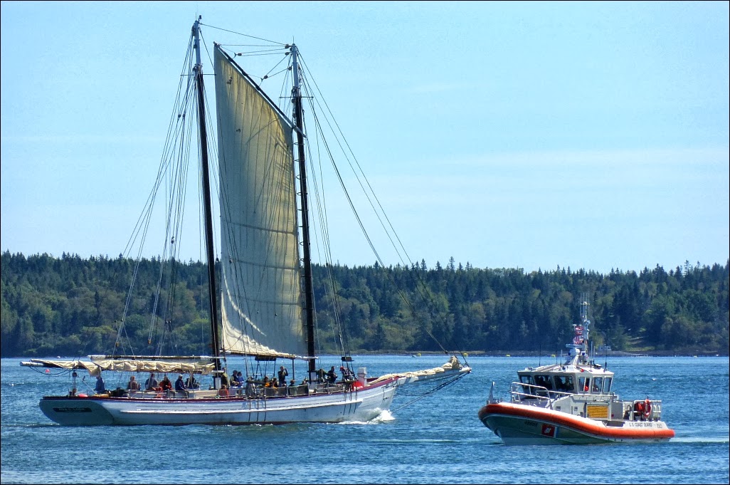
The schooner put up a foresail and motored out of the harbor, while a rugged U.S. Coast Guard crew came in from patrol.

Eastport is an active commercial harbor.


The morning after my return to the cottage at Branch Lake, I looked out and the world beyond the dock had disappeared in the mist.


