The Blue Ridge and Smokey Mountains further south might overshadow the mountain roads of West Virginia, but in the springtime, these winding, rolling asphalt trails, climbing, diving and hairpinning up and over gaps in the Allegheny ridges and following rivers through the hollows are almost, as the song says, heaven.
The only bison I saw riding over Buffalo Gap from Virginia to West Virginia was this one on the roof of a gas station.
With the goal of visiting Mammoth Cave National Park, I considered taking the Blue Ridge Parkway down to Roanoke and then ride west through Kingsport and Bristol, Tenn. before going north into Kentucky. But, on a whim, I went directly west from Waynesboro, Va., where the BRP starts, and climbed over Buffalo Gap and through West Virginia's George Washington and Monongahela National Forests.
At the overlook on the crest of the gap, I chatted with a couple riding a big Honda V-twin cruiser. I mentioned being impressed by a gorgeous country house, farm and airfield surrounded by miles of board fence on the way up the pass.
This country home caught my attention riding up over Buffalo Gap.
The rider, from nearby Virginia, said the spread was owned by a man who made a fortune "selling something to the airlines." Not only did he build the enormouse pillored mansion, but he built a second grand home that "looks like a bunker. He and his wife were divorced and he gave her the farm and built hisself another place. He's dead now, though."
They were out of cornbread at French's in Marlington.
After enjoying many miles of smooth, twisty, two-lane roads through budding forests next to burbling moountain streams, I stopped at French's Diner in Marlington which claimed to do "home cookin'."
William Least Heat Moon in his epic Blue Highways introduced a ranking system of country cafes based on the number of calendars on their walls. French's was a one-calendar diner. The menu listed only two items that promised to have local flavor: brown beans with cornbread and fish tail sandwich.
I asked the waitress if the fish tail was fresh. No, it was frozen and it wasn't really a tail, but a breaded square. With that bubble burst, I ordered the beans and corn bread. The waitress came back two minutes later to say they were out of cornbread and would I take a roll instead?
So I ordered a "cheeseburger dressed." Did dressed mean with fries? No, just lettuce, tomatoes and pickles. So, I ask for "seasoned curly fries" to go with the burger.
The fries, when they appeared, were neither seasoned nor curly, but they were at least hand cut from a real potato. Unfortunately, they were limp. Yup, a one-calendar kind of place.
In Richwood, W.Va. this gorgeous tree stood along the main road.
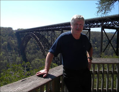
A few miles before arriving in Beckley, I came to the National River Gorge, a deep canyon cut by that river and spanned by the longest arched bridge in North America.
There's a good view of the bridge and gorge from a platform at the visitor's center.
I hiked down the winding wooden staircase and walkways from the visitor center to get a look at the bridge, which carries freeway traffic into and out of Beckley. A poster explained that the bridge was constructed of Core-Ten steel, which develops "a thin coating of protective rust." When I read that I thought I heard Frank Fasi roll over in his grave.
The walk down to the overlook was much easier than the climb back to the parking lot.
Coal mining dominates the scenery west of Beckley.
From Beckley, I headed west toward Kentucky only to find the GPS couldn't acquire satellite contact and was useless in the narrow valleys. I stopped at a gas station and asked for a road map. The woman at the counter looked at me in disbelief. Apparently, no one had ever asked her for a map before -- I suppose all her customers know where the roads go.
She sent me back the way I came to a Rite Aid drug store, which did have a map. Unfortunately, the roads in that part of the country seem to go in circles, connecting with each other but not with the outside world. I set off toward the setting sun, but the road, West Virginia 85, seemed to keep doubling back as it climbed and climbed between cliffs of drilled and blasted black rock oozing water. At the top, the road overlooked a valley billowing with smoke. Five or six cars were parked next to the road and a gaggle of people watched the spectacle.
The smoke, black cliffs, terraced, hillsides, coal grit on the shoulders of the road, remoteness and lack of GPS was not almost heaven. Not even close. More like the other place, .
Flags flew at half mast and signs throughout the state paid homage to the miners killed in nearby Coal River Valley.
I followed W. Va. 85 north until the GPS recovered and set a course for Lexington, Ky. By 7, I reached Charleston and found a motel. Big day: 352 miles.

It is good to be following your blog again, but I wish you were going to be coming back this way again. Taking a new route was a good idea. You had a long day, but several more adventures. Good luck tomorrow.
ReplyDeleteMJF